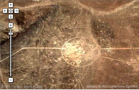
AREA 51 GROUND PICTOGRAMS
I received the following
e-mail from subscriber Gary Val Tenuda: "These pictographs
are located within 'area-51' satellite photos. These satellite
photos are quite interesting but puzzling. The person who sent
this to me assumed the geometric images were etched into the
ground. But it looks to me like they've been superimposed onto
the satellite photos. For instance, check out the one with the
circles inside the triangle (second link below). Notice the lines
of the geometric shapes are 'flat.' They don't seem to rise and
fall with the topography of the land. Still, even if these geometries
are superimposed upon the original photos, who did it and why?"
Anyone have any ideas?
Couleur de la photo rehaussée
avec photoshop.
Ci-bas la même
photo sattellite élargie...
J'ai rehaussé l'image en
lui donnant un peu de gain et moins de lumière. Assez
évident. Les Illuminati ou "Initiés des Announakis"
sont présents partout... même dans le désert
Source de la photo: http://maps.google.com/maps?ll=37.401952,-116.868720&spn=
0.004978,0.007703&t=k&hl=en |